


NavAtlas U.S. & Canada app for iPhone and iPad
Developer: Dual Electronics Corp.
First release : 09 Jan 2010
App size: 1.98 Gb
NavAtlas is a turn-by-turn, voice guided GPS navigation solution for iPod touch with text-to-speech (TTS) technology. NavAtlas, together with Dual’s GPS Navigation & Battery Cradle, turns any iPod touch into a fully-featured GPS navigator for in-car and handheld use.
IMPORTANT: This app works exclusively with XGPS300 GPS Navigation & Battery Cradle for iPod touch. NavAtlas will not work with other models of the GPS Cradle from Dual Electronics. The Cradle does not work with the iPhone.
If you have an iPod touch, and don’t want to miss out on all the great location-based apps, including turn-by-turn navigation, the Cradle is for you. It is the only complete, truly portable GPS navigation solution for iPod touch, featuring a built-in GPS Receiver, Rechargeable Battery, Amplified Speaker, and a Windshield Mount. It is ideal for in-car or handheld use - like biking, hiking or exploring a city on foot. In addition to the included NavAtlas navigation app, the Cradle provides GPS coordinates to most other location-based apps. Visit GPSCradle.dualav.com for more information on app compatibility.
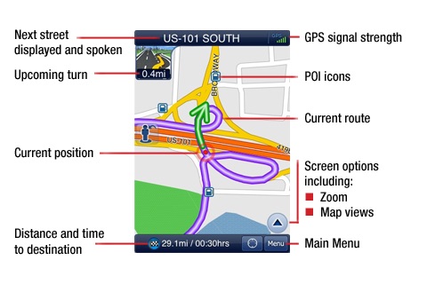
The NavAtlas app has all of the features commonly found in GPS navigation devices. The latest U.S. and Canada maps from Navteq™ are built-in, so there is no need for a Wi-Fi connection. There is no subscription fee - the app is free for use with the Cradle.
Key Functions:
- Real-time, turn-by-turn voice guidance to your destination
- Spoken street names using Text-to-Speech (TTS) technology
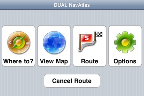
- Navigate directly to an address stored in Contacts on the iPod
- Navigate to a point on the map - touch anywhere on the map and the app will display the address of the location you have selected. You also have the option to navigate to this spot - this is especially useful when you know the approximate location of your destination but not the address.
- Play music on the iPod when navigating - music is automatically muted when directions are being spoken.
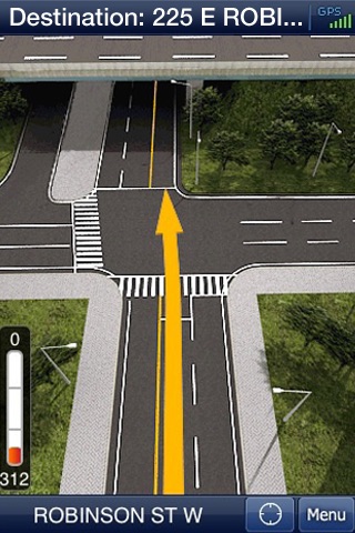
- Realistic 3D views of major urban intersections and highway junctions
- Portrait and Landscape modes
- Over 2 million of the most popular POIs, including restaurants, gas stations, hotels, tourist attractions, parks, hospitals, stores, businesses, ATMs, parking lots and many more.
- Create personalized lists of POIs – edit names of POIs or add notes (such as hours of operation) and save in “My POIs”.
- Features the latest U.S. and Canada maps from Navteq™ including Alaska, Hawaii and Puerto Rico
- Maps are built-in - no Wi-Fi connection required
- Flexible Trip Planning - enables you to select multiple destinations for one trip and to preview the routing among them all. Ideal when making numerous stops during one trip.
- Displays Favorites and POI icons - your favorite destinations and POIs are shown on the map.
- Day/Night Mode - switches between day & night map colors automatically
- iPhone-style interface - “pinch" the screen to zoom in and out, touch and drag the map to move, tap a button to bring current location back to center screen, etc.
- No subscription fee
Languages: English
Maps:
- U.S. (including Alaska, Hawaii, Puerto Rico)
- Canada
Requirements:
- Compatible only with iPod touch
- Requires iPhone OS 3.0 or later
- Requires the GPS Navigation & Battery Cradle for iPod touch (model XGPS300) from Dual Electronics.